
Yosemite National Park
Yosemite National Park is a national park and a UNESCO World Heritage Site in the Sierra Nevada mountains in east-central California. Approximately four million visitors each year come to Yosemite to marvel at its spectacular granite cliffs, towering waterfalls, remote wilderness, massive sequoia trees, and high mountain meadows.
Most read about in September, least in May. That is when people look it up, which tends to run a month or two ahead of when they go.
Before you book
The Foreign, Commonwealth & Development Office publishes the UK’s official travel advice for United States. It changes without notice and travelling against it usually invalidates your insurance, so read it at the source rather than anywhere else — including here.
FCDO travel adviceUnderstand
The park encompasses a massive 750,000 acres (300,000 hectares), 1,200 sq mi (3,100 km2) area and contains thousands of lakes and ponds, 1,600 mi (2,600 km) of streams, 800 mi (1,300 km) of hiking trails, and 350 mi (560 km) of roads.
History
Humans may have first visited Yosemite as long as 8,000 years ago, and there is evidence that people have lived in the area for nearly 4,000 years. In 1849 the lives of the native Miwok population changed dramatically as the California Gold Rush brought thousands of miners into the region, resulting in a massive disruption to the way of life practiced by the existing people. By the 1930s the population of Native Americans had dwindled to the point that the last Indian village was disbanded, and by 1969 the last private Indian residences (by then solely inhabited by park employees and their families) were abandoned. The beauty of Yosemite Valley inspired early visitors to the area and led to concern about exploitation by commercial interests. After prominent individuals advocated for its protection, on June 30, 1864 President Abraham Lincoln signed a bill granting Yosemite Valley and the Mariposa Grove of Giant Sequoias to the State of California as an inalienable public trust. This was the first time in history that the US federal government had set aside scenic lands for the purpose of preservation and public use. Following further lobbying by the conservationist John Muir, additional restrictions were put in place against grazing in the subalpine meadows surrounding Yosemite Valley, and on October 1, 1890 the area was declared America's third national park. However, as Mackinac River National Park in Michigan became a state park, Yosemite is the second oldest that still holds the "national park" title today. Despite its national park status, California controlled the initial grant area until 1906. Following the 1906 San Francisco earthquake that city began looking to Yosemite's Hetch Hetchy Valley as a source of drinking water and hydroelectric power, and a bitter political struggle ensued between environmentalists and the city. In 1913, with the passage by Congress of the Raker Act, permission was granted to San Francisco to build the O'Shaughnessy Dam, allowing the Tuolumne River to flood the valley. Today, efforts to remove the dam and restore the Hetch Hetchy Valley continue.
Landscape
Yosemite is best known for its impressive granite cliffs and domes. These formations were born approximately ten million years ago when the Sierra fault began uplifting the Sierra Nevada mountains, forming relatively gentle western slopes and more extreme eastern slopes. Erosion, combined with at least four glacial periods, exposed the underlying granite and resulted in many of the cracked, rounded, and weathered formations that make the park famous. Streams cut deep, narrow valleys, while glaciers covered the area in up to 4,000 ft (1,200 m) of ice and generated wide, U-shaped valleys. The Tuolumne and Merced rivers are the two major river systems in the park, carving canyons that are 3,000 ft (910 m) to 4,000 ft (1,200 m) deep. In addition, smaller rivers flow through the extreme elevations, generating some of the most impressive waterfalls in the world. In Yosemite Valley, Yosemite Falls, at 2,425 ft (739 m), is the tallest waterfall in North America, while Ribbon Falls has the highest uninterrupted vertical drop at 1,612 ft (491 m).
Getting there
By car
There are no gas/petrol stations in the Yosemite Valley. However, electric vehicle charging stations are available. There are four major entrances into the park. All of these routes are relatively winding mountain roads and appropriate time should be budgeted for them.
State Route 120 from the west from Oakdale. This is the fastest route from locations west (Bay Area) and northwest (Sacramento). Route 120 is a bit steep, so RVs and trailers should consider Route 140 instead. In winter, snow makes the lower elevations of Route 140 more attractive. State Route 140 west from Mariposa and Merced. This route mostly travels up the Merced River Canyon into Yosemite Valley and is the most scenic western entrance. RV and tour bus traffic used to congest this road a bit too much in summer, but the Ferguson rockslide in 2006 has caused restrictions to be imposed that prevent vehicles longer than 45 ft (14 m). Highway 140 is now pleasantly less congested and the bridges afford an excellent view of the massive rock slide. State Route 41 north from Fresno and Los Angeles/Southern California. Be sure to fill your gas tank in Oakhurst (several stations along highway), or pay dearly as you get closer to the park. Many businesses (including two more gas stations) are on the first half mile of adjoining State Route 49 in Oakhurst. State Route 120 from the east (Tioga Pass Road) from Lee Vining and points east. This road is only open when free of snow (usually May - October) so check road conditions in advance. A secondary entrance exists to Hetch Hetchy Reservoir exclusively (no Yosemite Valley access) off of State Route 120 from the west. It requires taking a side road near the main Route 120 west entrance of Yosemite. Hetch Hetchy has restricted hours for access due to security for the Reservoir. During the snow season, usually November through March, snow chains may be required. Chain requirements are strictly enforced in Yosemite with potential fines being as much as $5,000, so chains should be carried during those months. During summer months traffic becomes heavily congested in Yosemite Valley, and parking can be nearly impossible to find. Summer visitors to Yosemite Valley are therefore strongly encouraged to use the YARTS shuttle system (see below) to get into the park.
By plane
There are no landing strips within the park. Airports in surrounding communities include:
Getting around

Yosemite has grown from a little visited, yet historically significant, park to one of the "crown jewels" of the US National Park System. With this stature comes difficulties; Yosemite is the third most visited national park in the United States, with an annual visitation of approximately 4 million, and a majority of those visitors are concentrated in the 12 sq mi (31 km2) within Yosemite Valley (about 1% of the total park land).
By car
With most of the park visitors destined for Yosemite Valley, traffic and parking are significant problems during the busy summer season. As a result, while a car is a great way to tour the park, if visiting the Valley, taking YARTS and the shuttle bus may be a vastly better option. Be aware that the Tioga Pass Road and the road to Glacier Point are seasonal and close as soon as the first major snow falls. Other park roads may close during storms, but in general are always open. The speed limit in all areas of the park is fairly slow, and is strictly enforced by rangers with radar guns; the speed limits are for your own safety on the twisting mountain roads, as well as for the safety of pedestrians and the many animals that use the area. The loop road through Yosemite Valley is now one-way. For many years this was a two-lane road, but motorists travelling slowly to admire the scenery often created a long backup of annoyed drivers, so the Park Service converted most of the roads in the valley into one-way roads to allow passing. As a result, when driving in the valley be aware that a wrong turn can send you on a one-way 5 mi (8.0 km) detour. The one-way routing affects those entering from Oakdale on Hwy 120 the most. You will have to cross over to Southside Drive at the Pohono Bridge. Likewise upon leaving the park, those taking the south exit on Hwy 41 to Fresno also cross the Pohono Bridge, backtrack 1 mi (1.6 km), before turning right onto Wawona Road.
Fuel stations
There are three fueling stations in Yosemite. Fuel may be paid for with a credit or debit card 24-hours a day. The stations can be hours away from your location in the park––if you are running even a little low on gas, it's advisable to fill up at the closest station despite regular wait times of 15-20 minutes or more.
See

If you only have a single day to visit the park, a drive around Yosemite Valley is probably the best option. Longer visits provide options for hiking, visiting sites outside the Valley, and getting a fuller experience of what the Sierra Nevadas have to offer. Visiting in winter provides the opportunity to see dramatic winter landscapes in Yosemite Valley or to ski in Badger Pass, but much of the park will be inaccessible due to winter road closures. Spring is the best time to see the waterfalls at their strongest. During the summertime all park roads are open, and Tuolumne Meadows will be snow-free and full of flowers. The Fall offers a time with smaller crowds, cooler weather, and access to the entire park (unless there is an early snowstorm). The vast majority of tourists to Yosemite will spend almost all of their time in Yosemite Valley––returning visitors and experienced travelers alike would be well-served to avoid the valley and explore the rest of the park, which is considerably less developed and trafficked but equally, if not more, beautiful.
Yosemite Valley
Yosemite Valley is the reason why Yosemite was America's first place set aside by the federal government for its scenic beauty. The cliffs rise around the valley at impossibly vertical angles, waterfalls tumble down unimpeded from a thousand feet (300 m) above, and the Merced River meanders aimlessly along the valley floor. The Valley is also one of the most accessible places in the park, with roads open year-round and plenty of amenities including lodging and food (but no gas stations). During summer months traffic can make the valley highly congested, so consider using the shuttle to cut down on stress. Those entering the valley via Highway 41 will be treated to the spectacular viewpoint known as Tunnel View. Named for the tunnel that bores through the granite, the eastern side provides a dramatic view of Yosemite Valley with 1 El Capitan on the left, Bridalveil Fall on the right and Half Dome in the center. Photographers should consider this area for pictures after storms, as many of the most famous pictures of the Valley have been taken from this spot as rough weather clears. There are two small parking lots that can get congested, so arrive early in the day if visiting during Summer to ensure a spot. The sights in the valley include the granite monolith of 2 Half Dome, a mountain that looks like it was split in two, leaving only a vertical face and rounded granite summit behind. In reality Half Dome was formed in the same way that many of Yosemite's granite formations were created - long ago an intrusion of magma deep underground solidified to form a massive granite block, and that block was eventually exposed to the surface via a combination of erosion and uplift. Glaciers that flowed through Yosemite did the rest, carving out the wide, U-shaped valleys that are bordered by sheer vertical walls. These same forces created the wall of El Capitan, a mecca for rock climbers and another of the Valley's famous formations. Waterfalls in Yosemite Valley include 3 Yosemite Falls, one of the highest waterfalls in the world at 2,425 ft (739 m). Bridalveil Fall is another easily accessible waterfall, while Nevada Fall and Vernal Fall can be reached by those willing to do some hiking. While some water flows over the waterfalls year-round, by mid-Summer flows are significantly diminished - plan on visiting in the Spring to see these waterfalls at their grandest. Yosemite is one of two places in the US – the other is Cumberland Falls State Resort Park – where "moonbows", or faint nighttime rainbow produced by the moon's light, can be seen. When the water is flowing and the moon is near the full, you may be able to see one, if you're in the right spot and have sharp eyes. https://www.yosemitemoonbow.com/ has predicted days, times, and locations for these special moments.
Wawona
Wawona is the home to the historic Wawona Hotel, dating from the late nineteenth century. The Pioneer Yosemite History Center, a collection of historic buildings, is just over the covered bridge from the hotel. Wawona is accessible by car year-round. The 4 Mariposa Grove is the largest of the three giant sequoias groves in the park (the Merced Grove and Tuolumne Grove are the other two) and is home to over 500 mature trees. While not the tallest or oldest things on earth, by volume the giant sequoias are the largest living organism known to man. The grove is south of Wawona near the entrance station, with parking available in a lot located 2 mi (3.2 km) from the grove, and a shuttle bus available to bring visitors from the parking lot into the grove. Trails lead from the Lower Grove to the Upper Grove - traversing the entire route is a 3-4 mile (5-6 km) hike, depending on the paths chosen. Trees within a short walk of the lower parking area include the Grizzly Giant, a massive 1800 year old tree, and the California Tunnel tree, which was cut in 1895 to allow carriages to pass through. Further on, in the Upper Grove, is the Clothespin Tree, which has a natural tunnel in it created by fire that is large enough for a car to pass through, the Wawona Tunnel tree, another tree with a man-made tunnel in it that fell in 1969, and the Telescope Tree, a living tree that is hollow inside, allowing visitors to enter its trunk and stare upwards.
Do
Hiking
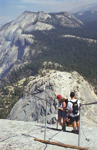
Yosemite is one of the world's most spectacular hiking destinations, and all visitors should consider at least a short hike. The Vernal Fall trail is a short and rewarding trek for valley visitors, numerous trails in the high country along Route 120 are suitable for brief trips to see alpine lakes or granite domes, and the sequoia groves all offer the option of short hikes that can easily be extended. More adventurous and physically-fit hikers might consider the Half Dome trail or any of the park's backcountry trails. Prior to hiking check with rangers for trail conditions; snow and hazards from falling rock close many trails in winter, and the cables on the Half Dome trail are only up from late May through early October (ascending Half Dome when the cables are not erected is possible but is dangerous and strongly discouraged). No permits are required park-wide for day hikes, with the exception of the Half Dome Summit.
Yosemite Valley
Many of the meadows have short trails, some of which are handicap accessible. For those staying in the valley, walking to get around is easy, scenic, and avoids the stresses of car travel in the valley.
1 Lower Yosemite Fall (1 mi (1.6 km) loop), Starts at the Lower Yosemite Fall shuttle bus stop (#6). This flat, easy, paved one-mile loop trail leads to the base of Yosemite Fall and provides views of the waterfall along the way. During the spring the sound of the water is deafening, although it may be nearly dry by late summer. There is no parking at the trailhead, but there is a shuttle stop. The eastern part of the loop is wheelchair accessible. (updated Dec 2021) 2 Bridalveil Fall (0.5 mi (0.80 km) round-trip), Starts from the Bridalveil Fall parking area. Another flat, easy, paved trail that leads to the bottom of the 620 ft (190 m) Bridalveil Fall. Parking is available at the trailhead. Despite being paved, the trail is not wheelchair accessible due to the grade (it ascends 80 ft (24 m) in elevation). The trailhead to this fall is on the Southside Dr, so it's best to visit it on your way to the Valley. (updated Dec 2021) 3 Cook's Meadow Loop (1 mi (1.6 km) loop). This flat, easy loop trail meanders through the meadow across from the visitor center and near the Lower Yosemite Fall trail, offering excellent views of Half Dome, Yosemite Fall, Glacier Point and Sentinel Dome. From the visitor center, walk west along the bicycle path toward Lower Yosemite Fall. At shuttle stop #6, cross the street and follow the bike path, bearing left as the path forks. At Sentinel Bridge parking area (shuttle stop #11), walk out onto the bridge to enjoy a classic view of Half Dome before returning to the parking area. Follow the boardwalk back across the meadow, cross the two streets, and turn right to return to the visitor center. (updated Dec 2021) 4 Mirror Lake/Meadow (2 mi (3.2 km) to Mirror Lake, 5 mi (8.0 km) around the lake), Starts from the Mirror Lake trailhead shuttle bus stop (#17). The first mile of the trail follows a paved service road and eventually leads to what is a large pond in spring and a meadow the rest of the year. When it contains water the lake reflects Half Dome, but even when the lake is dry the meadow still offers scenic views. Those who are interested can also hike around the lake bed and along Tenaya Creek. (updated Dec 2021) Valley Floor Loop (6.5 mi (10.5 km) round-trip with cutoff, 13 mi (21 km) without). The loop trail around Yosemite Valley can be hiked in pieces or in full as it travels through meadows, forests, and beside the Merced River, offering great views of Yosemite Valley. Following the road in places, the trail can be shortened by crossing the bridge just east of El Capitan Meadow. The majority of this trail network is wheelchair accessible with the exception of the Superintendent's Bridge and a steep section near Housekeeping Camp. (updated Dec 2021) 5 Vernal Fall (Mist Trail) (2.4 mi (3.9 km) round-trip), Starts from the Happy Isles shuttle bus stop (#16). This trail gradually gains 400 ft (120 m) of elevation along the Merced River by the time it reaches a footbridge offering an excellent view of the 317 ft (97 m) high Vernal Fall. From the footbridge the trail quickly gains another 600 ft (180 m) of elevation as it traverses steep and often slippery granite steps to the top of the waterfall, but the view is hugely impressive and worth the exertion. The Mist Trail is one of the busiest trails in the park during the high season––returning visitors might want to consider a hike outside the valley. From the top of Vernal Fall hikers can continue on to Nevada Fall. (updated Dec 2021) 6 Nevada Fall (Mist Trail) (5.4 mi (8.7 km) round-trip), Starts from the Happy Isles shuttle bus stop. Nevada Fall is a 594 ft (181 m) waterfall 1.5 mi (2.4 km) beyond Vernal Fall. The trail from the top of Vernal Fall is relatively easy and passes through a pleasant stretch of the Merced river with several pools (beware of currents!) surrounded by impressive granite cliffs before leading up a steep series of steps to the top of the waterfall. The John Muir trail is a more gradual ascent that can be undertaken from the junction near the Vernal Fall footbridge, but those who choose that route will forgo the view from the top of Vernal Fall as well as the scenery along the Merced River; consider ascending on the Mist Trail and descending on the John Muir trail if you want to enjoy the scenery but limit the trauma to your joints. The total elevation gain from the Happy Isles trailhead to the top of Nevada Fall is 2,000 ft (610 m). (updated Dec 2021) 7 Panorama Trail (8.5 mi (13.7 km) one-way), Starts from Glacier Point. The Panorama Trail offers panoramic views of the valley and passes by three of Yosemite's most impressive waterfalls, although you'll likely only see two of them; while Vernal Falls and Nevada Falls are easily viewed, there is no viewpoint of 370 ft (110 m) tall Illilouette Fall despite the fact that the trail crosses Illilouette Creek only a short distance from the top of the waterfall. Panorama Point is accessible via an easily-missed 300 ft (91 m) unmarked side trail that can be found 0.5 mi (0.80 km) from the Illilouette Creek bridge and is a detour that should not be skipped. From late May/early June through October, a fee-based hikers bus will take you up to Glacier Point, where you can then hike two downhill miles to Illilouette Creek, ascend 700 ft (210 m) in elevation over 1.5 mi (2.4 km), and eventually descend on either the Mist Trail or the John Muir Trail back down to the valley floor, ending at Happy Isles. (updated Dec 2021) 8 Four Mile Trail to Glacier Point (4.8 mi (7.7 km) one-way). The trail follows switchbacks from Glacier Point and offers spectacular views up and down Yosemite Valley. Hikers can take the shuttle bus from the valley to Glacier Point and then hike down, or those looking for an extremely strenuous hike can ascend starting from the Four Mile Trailhead just west of Swinging Bridge picnic area. Visitors interested in a long day hike can make a loop on this trail with the Panorama Trail. (updated Dec 2021) 9 Upper Yosemite Fall (7.2 mi (11.6 km) round-trip), Starts near the Camp 4 shuttle bus stop. One of the oldest trails in the park, the Yosemite Fall trail was built back in 1873 and ascends 2,700 ft (820 m) from the base of the 2,425 ft (739 m) high Yosemite Falls all the way to the top of the waterfall. The first 1 mi (1.6 km) ascends 1,000 ft (300 m) steeply to Columbia Rock, which offers exceptional views of the valley and Half Dome. A less strenuous 0.5 mi (0.80 km) further along the trail offers views of the upper Yosemite Fall. The second half of the trail is equally strenuous, but the incredible views reward those who choose to continue. In summer bring plenty of water and begin hiking early as the trail becomes extremely hot and dusty. (updated Dec 2021) 10 Half Dome (17 mi (27 km) round-trip), Starts at the Happy Isles shuttle bus stop. One of the most spectacular trails in the world, the Half Dome trail travels past Vernal Fall, and Nevada Fall, and then continues rising through a pine forest before opening up near the summit of Half Dome. The final mile is a grueling trek up granite steps, followed by wire cables that lead up the steep ascent to the top of Half Dome. Hikers should bring leather work gloves to protect their hands from the cables; some gloves are often available in a pile at the bottom of the cables. While it is possible to ascend Half Dome while the cables are down (between approximately October 15 and May 15), hikers do so at their own risk. Views and scenery are unforgettable, but hikers should be aware that the final climb up the back side of Half Dome via the cables can be exhausting and, for those with even a mild fear of heights, frightening. It's best to wear a safety harness and tethers, because parts of the cable route are extremely steep and slippery. Safety harnesses have saved many lives on what's considered the most dangerous hiking trail in the US, especially on wet days. While the majority of the trail is accessible without a permit, an $10 permit is required to traverse the final stretch of the trail beyond the base of the Half Dome subdome. 300 permits are available each day (approximately 225 to hikers and 75 to backpackers), with rangers stationed on the trail to turn away hikers without permits. Permits can be obtained in advance via a pre-season lottery (apply online between March 1 and March 31, permits issued in mid-April, an additional online application fee of $4.50 applies), and approximately 50 permits are made available in an evening lottery two days prior to the hiking date. (updated Jun 2026)
Shopping
Souvenir shops abound in Yosemite. Stores are run by the park concessionaire (Aramark), the Yosemite Conservancy, or the Ansel Adams Gallery, with a few smaller family stores. Aramark, YC, and the Ansel Adams Gallery offer some form of mail order. The Yosemite Conservancy stores specialize in educational materials about Yosemite, many of which are published by the organization; membership offers a 15% discount on most purchases. Gas is available for purchase at Crane Flat, Tuolumne Meadows, Wawona, and in towns outside of the park. Gas prices tend to be 60 cents to 1 dollar higher than communities like Fresno, Merced, and Modesto.
Yosemite Valley
1 The Ahwahnee Gift Shop, 1 Ahwahnee Dr, ☏ +1!209-372-1409Phone with wrong format. 8AM-8PM. The souvenir shop inside of the Ahwahnee Hotel features American Indian pottery, kachinas and jewelry as well as more standard fare like photographic prints, books and clothing. 2 Ansel Adams Gallery (Yosemite Village), ☏ +1 650-692-3285. 9AM-6PM. This gallery first began operating in Yosemite Valley in 1902, and is now operated by the fourth generation of the family that started it. Ansel Adams started a business relationship with the gallery in the 1920s, and today the gallery features his work in books and prints. In addition, the gallery offers exhibitions of contemporary photographers, with exhibits rotating approximately every six weeks, and staff can provide photography advice for those seeking it. In additions to the works of Ansel Adams, the gallery has an extensive collection of books for sale, works by other photographers, Native American and contemporary jewelry, and handcrafted pottery. Offers a 10% discount for Yosemite Conservancy donors. 3 Curry Village Gift Shop. 9AM-7PM. Serving as a "camp store", you can find souvenirs as well as groceries, picnic supplies, apparel, ice, firewood, batteries and an ATM. 4 Mountain Shop at Curry Village, 9032 Village Dr (Curry Village), ☏ +1 209-372-8396. 8AM-5PM. The best sport shop in Yosemite, and one of the best rock climbing gear stores in the world. 5 Habitat Yosemite. Th-Su 11AM-4PM, closed in winter. In the Degnan's building in Yosemite Village, the store specializes in environmentally friendly products. 6 Housekeeping Camp Store. Seasonal. Best described as a combination between Curry Gift and the Village Sport Shop. 7 Museum Store. Operated by the Yosemite Conservancy. 8 The Nature Shop (Yosemite Valley Lodge). 11AM-6PM. All merchandise has a "natural" bent but relatively low prices compared to the Ahwahnee Hotel Gift Shop. Low visitation to this store makes it desirable for quiet shopping. 9 Village Store, ☏ +1 209-372-1253. The largest store in Yosemite, with the largest grocery selection as well. If you need something for your visit, check here first. 10 Yosemite Valley Lodge Gift Shop. 8AM-7PM. Extremely similar to the Curry Village Gift Shop. Caters mostly to Lodge guest, Camp 4 campers, and tour groups.
Other locations
11 Mariposa Grove Museum (Wawona). Seasonal. Operated by the Yosemite Conservancy. 12 Tuolumne Meadows Store. Seasonal. Well visited by long-distance hikers, as the PCT and the JMT go right by the store, it has camp supplies, souvenirs and snacks. Pioneer Gift & Grocery (Wawona, see under Sleep section). 8AM-5PM. Servicing the southern end of Yosemite, this store has groceries, souvenirs, books, fishing supplies, apparel, and a decent wine selection.
Eat

Groceries can be purchased in Yosemite Village, Crane Flat, Curry Village, Wawona, and Tuolumne Meadows.
Yosemite Valley
The Ahwahnee Hotel Dining Room (see under Sleep section), ☏ +1m209-372-1489Phone with wrong format. An upscale restaurant in Yosemite Valley serving breakfast, lunch and dinner. Famous also for its Sunday Grand Buffet. There is a "resort casual" dress code for dinner service, meaning shorts and jeans are not acceptable attire, and that dinner reservations are recommended. Breakfast and Lunch attire remain regular casual. 1 The Mountain Room. Open daily year-round, this dining room is in Yosemite Valley Lodge and offers dinner with a view of Yosemite Falls. A significant portion of its menu includes organic and sustainable food. Food and service that's just as good as the Ahwahnee Hotel with menu prices that are 20% less and without the dress code. Reservations are not taken for parties of six or less. 2 Yosemite Valley Lodge Food Court, 9006 Village Dr, Yosemite Valley. 7AM–8PM. Serving cafeteria-style meals in Yosemite Valley Lodge. Offers breakfast, lunch and dinner year-round. 3 Degnan's Deli. Open year-round and offering standard deli fare, in Yosemite Village. 4 Degnan's Loft. Open to the public from April to October from noon to 9PM, offering pizza, salads and soups in Yosemite Village. Open only to park employees and residents November through March from 5PM to midnight (last call at 11:30PM). Pizzas and salads are available only from 5PM to 9PM. They also add pool tables and video games during the winter. They are removed during tourist season to maximize seating. 5 Degnan's Cafe. Next to Degnan's Loft, serving "grab-and-go" food like sandwiches and chips, coffee and soft-serve ice cream. Open summer season. 6 Village Grill, Yosemite National Park Rd. Fast food in Yosemite Village. Open from Spring through Fall. Closes for the day if weather is poor. 7 Curry Village Pavilion Buffet. In Curry Village, offers a breakfast and a dinner buffet. 8 Curry Village Taco Stand. Burritos, tacos, nachos, ice cream and beverages. Open Seasonally from April to October. 9 Curry Village Pizza Deck. Pizza and salads. Open March through December. The food offered is nearly identical in quality and price as the Loft, but if crowds aren't your cup of tea then it might be best to avoid this establishment. 10 Curry Village Ice Cream & Coffee Corner. Open March through December. The ice cream bar closes in mid September. 11 Happy Isles Snack Stand. Offering drinks and snacks during the summer near the Happy Isles nature center. Handy when you come off the trail, and want something.
Wawona
Wawona Hotel Dining Room (see under Sleep section). Fine dining, serving breakfast, lunch and dinner daily, with a brunch served on Sundays. Wawona Lawn Barbecue (see under Sleep section). (summer) Sa 5PM-7PM. On Saturday evenings in summer the lawn outside of the Wawona Lodge hosts a barbecue featuring steak, chicken, hamburgers and corn-on-the-cob. Wawona Golf Shop Snack Stand (see under Do section). Snacks, beer, and other beverages on the golf course. Open daily from spring through fall.
Drink
The Ahwahnee Hotel Lounge (see under Sleep section). An upscale lounge in Yosemite Valley, offering cocktails, wine, beer, and bar food (sandwiches, appetizers, salads) with seating available both inside and on the terrace. Opens at 11AM daily, with live piano music most Friday and Saturday evenings. 1 Mountain Room Lounge (Yosemite Valley Lodge). In Yosemite Valley Lodge, this lounge offers cocktails and bar food. Televisions are also placed around the room for those who have escaped to Yosemite but can't bear to miss the game. 2 Pavilion Bar (Curry Village). In Curry Village, this bar serves cocktails, beer, wine and fast food with inside and deck seating. Extremely popular among employees. Seasonal. Wawona Hotel Cocktail Service (see under Sleep section). Within the Wawona hotel a cocktail service is available in both the lounge and on the veranda. Singing piano player performs certain nights.
Sleep

Demand for lodging in Yosemite Valley in both the hotels and the campgrounds is extremely heavy during the peak season, so you need to book well ahead of time during the late spring, summer and early fall; vacancies are more common during the off-season. As an example, by mid-May in 2015 not a single reservation remained in any campground for any night during the summer season. Cancellations occur on a random basis, so it is also advised to call back frequently for a desired reservation date. Cheaper and more abundant lodging can be found outside the park. The nearby towns of El Portal, Mariposa, Groveland, Fish Camp, and Lee Vining have lodging. In addition, the community of Yosemite West borders the park and offers numerous rentals; it is accessible only from within Yosemite and provides a convenient option to visitors planning to stay near Wawona or Yosemite Valley. Be aware that despite names like "Yosemite View", no lodging outside the park has a view of the Valley. Lodging is particularly close to the park near the Route 140 entrance and the Route 120 East entrance; for those approaching from the Route 41South entrance, there are many affordable lodging options in Oakhurst, but at the cost of a longer commute distance. In addition, Yosemite is surrounded by national forests that offer numerous campgrounds.
Park lodging
The following lodging options are operated by the National Park Service through a concessionaire.
1 The Ahwahnee Hotel (formerly The Majestic Yosemite Lodge), 1 Ahwahnee Rd, ☏ +1 801-559-4884. For those looking for absolute luxury while surrounded by Yosemite Valley, this hotel is a national historic landmark that is known for its massive stone hearths, granite facade, Native American artwork, and upscale service. The restaurant offers gourmet cuisine, rooms face Half Dome, Glacier Point and the West Valley, and there is a small heated pool. 99 luxury hotel rooms, three of which are fully accessible rooms, four partially accessible. There are also 24 cottages, two of which are fully accessible. Rooms and cottages start at about $500 per night, with suites running up to and above $1000 per night. (updated Feb 2015) 2 Curry Village (formerly Half Dome Village), 9010 Curry Village Dr, ☏ +1 801-559-4884. Check-in: 5PM, check-out: 11AM. In Yosemite Valley, Curry Village offers a wide range of lodging options ranging from "hotel" accommodations to primitive tent cabins. No cooking is allowed at Curry Village and tent cabins also come with a bear locker to store food. There is an outdoor pool, which is free to people lodging there and open to the public for $5. The entire complex includes 46 cabins with private baths, 14 cabins without private bath, 18 standard motel rooms, and 424 canvas tent cabins without private bathrooms. There are five bathroom buildings and one shower building in the camp. There are two cabins, one hotel room, and six canvas tent cabins that are accessible. Rates for tent cabins are approximately $125 per night, while cabins and motel rooms are from $125 to $200 per night. (updated Feb 2015) 3 High Sierra Camps, ☏ +1 801-559-4884. The five High Sierra Camps are villages of tent cabins in Yosemite's backcountry, with most of the tent cabins holding four people (be prepared for mixed gender sleeping arrangements). Due to their remote locations the High Sierra Camps are normally visited as part of a horseback package tour or a hiking trek, with each camp spaced a day's hike apart. All of the High Sierra Camps include gourmet breakfast and dinner, and eat-in only reservations may be possible for those not needing accommodation. The High Sierra Camp cooking is widely regarded by locals as some of the best food in Yosemite. Some lodges may have hot showers, and all require that you bring your own linens. Demand for the High Sierra Camps is so high that reservations are handled by a lottery held from October 15 to November 30 (call for an application) with final assignments decided by March 31. Be aware that it is sometimes possible to get a High Sierra Camps reservation later if someone cancels. $145 to $151 per night for adults and $87 to $91 per night for children (age 7-12). 4 Housekeeping Camp, ☏ +1 801-559-4884. Despite its name, Housekeeping Camp (near Curry Village) offers 266 sturdy tents for visitor lodging. The "tents" have a concrete floor, three concrete walls, canvas tops, a bunk bed, a double bed, and two cots, providing sleeping for up to six. Linen is not provided but may be rented for $2.50 per night. Separate restrooms and shower facilities are within walking distance of the cabins. Open from April through October only. Housekeeping Camp is the only lodging in the Valley that allows for a fire and cooking. $80-$110 per night. (updated Mar 2015) 5 Tuolumne Meadows Lodge, ☏ +1 801-559-4884. Open from mid-July through September, Tuolumne offers 69 tent cabins in Tuolumne Meadows. These tent cabins have wooden frames, a concrete floor, and canvas walls. Bunks beds, linens, candles, and a wood stove are provided, while bathrooms and showers are in a central facility. $107 per night. 6 Wawona Hotel (formerly Big Trees Lodge), 8308 Wawona Rd, ☏ +1 801-559-4884. Check-in: 5PM, check-out: 11AM. This national historic landmark overlooks Wawona Meadow in the south part of the park along Route 41. Of the 104 rooms only 50 have a private bath. The lodge is rustic, with no telephones or televisions. In the winter months the lodge is only open on select weekends and holiday periods. Rooms rates are approximately $300 for a room with a private bath, and $150 without. Rates are slightly lower in the winter. (updated Feb 2015) 7 White Wolf Lodge, ☏ +1 801-559-4884. Along the Tioga Pass Road, White Wolf is open from July through September and offers 24 tent cabins and 4 cabins with private bath. The tent cabins are wood frame on a raised wooden platform and include beds, linen, and a wood stove. The lodge was renovated in 2015, including mechanical, structural, electrical and plumbing fixes, as well as ADA enhancements. Rates are $140 per night for tent cabins without bath. (updated Jan 2017) 8 Yosemite Valley Lodge, 9006 Yosemite Lodge Dr, ☏ +1 801-559-4884. Check-in: 5PM, check-out: 11AM. Near the base of Yosemite Falls, this lodge offers 245 rooms, none of which have air conditioning. Internet access (in-lobby kiosks and WiFi in guest rooms) is now also available. There is an outdoor pool on the premises, as well as the main activities desk for the park. There are five accessible rooms. The public facilities are accessible and most walkways are paved. Room rates are $250-300 per night, with slightly lower prices during the winter. (updated Feb 2015)
Stay safe
For any emergency in Yosemite National Park, dial 911 from most phones (hotel and retail phones may require 9+911). Yosemite NPS runs its own dedicated emergency dispatch. If you dial from a cell phone, first mention that you are in Yosemite as many cell phones route to a call center in your number's area code.
Medical
5 Yosemite Medical Clinic, 9000 Ahwahnee Dr (Yosemite Valley), ☏ +1 209-372-4637. Drop-in and urgent care May-Sep: daily 9AM-7PM; Oct-Apr: M-F 9AM-5PM. Routine and emergency medical care, 24-hour paramedic/ambulance services, lab, and Mountain Crisis Services for victims of domestic violence. (updated Apr 2015)
Wildlife
Over the years the park's bears have become accustomed to scavenging trash and food left out by humans, and will even break into cars and tents to get it. While not the larger grizzly bears that once roamed California, black bears are strong enough to tear a door off of a car with ease. Luckily they usually prefer to avoid humans, so they'll most likely do their work on vehicles left at trailheads or in parking lots. Prevention is remarkably simple: never leave food or scented items (deodorant, air fresheners) in your car or bring them into your tent. Heed this advice! Leaving even just a tube of toothpaste or empty food wrappers in a car may result in thousands of dollars of damage to your vehicle should a bear choose to investigate the smell! Bear-resistant storage units are provided at park campgrounds and overnight parking areas: use them. To avoid bear encounters while hiking, make noise so that the animal knows you are coming. This approach will also help to avoid encounters with mountain lions, which also inhabit the park. Other animals, such as the herds of deer which can be found in the park's meadows, can be equally dangerous; a young boy was killed by a deer in Yosemite Valley several years ago. Give all animals their space, and never feed any park wildlife.
Go next
The towns of El Portal (west on SR140), Mariposa (west on SR140), Groveland (west on SR120), Fish Camp (south on SR41), Lee Vining (east on SR120) and Yosemite West (midway between Yosemite Valley and Wawona) are all within a few miles of the park border. Other nearby destinations include:
Devils Postpile National Monument. This national monument protects a formation of lava basalt columns formed 80,000 to 100,000 years ago, and also provides an access point to the High Sierra wilderness. The monument is about 40 mi (64 km) south of Yosemite off of highway 395. Sequoia and Kings Canyon National Parks. The most extensive groves of the world's largest trees can be found approximately 125 mi (201 km) south of Yosemite. Sequoia and Kings Canyon are managed as a single unit and provide access to vast groves of giant sequoia trees as well as a huge network of trails that lead to some of the most pristine and remote areas of the High Sierra. Mount Whitney, the highest summit in the contiguous United States with an elevation of 14,505 ft (4,421 m), is within the borders of Sequoia. There is no vehicle access to these parks via US Highway 395, though it's much easier to get a good view of Mt. Whitney this way. To enter, take State Highway 41 (south exit) to Fresno, then State Highway 180 (in downtown Fresno) to Kings or State Highway 198 (via Visalia) to Sequoia. Tuolumne County, California's historic gold mining country of the mid-1800s. Towns include Jamestown, Sonora, and Columbia. Take State Highway 120 west to State Highway 49 north (turn at Parrott's Ferry Rd. [E-18] for Columbia). Mono County - Yosemite's eastern gateway, remote and expansive Mono County is a destination for outdoor enthusiasts. It is home to the Old West ghost town of Bodie, as well as Mammoth Lakes, a favorite winter skiing getaway. The gigantic Mono Lake is perhaps the county's premier attraction, a stopover for millions of migratory birds and thousands of tourists who explore its alkaline waters and bizarre tufa formations. Manzanar National Historic Site During World War II more than 100,000 Japanese Americans were interned in camps, the largest and best preserved of which is between the towns of Independence and Lone Pine off US Highway 395, about 125 mi (201 km) south of Yosemite. Manzanar is situated in one of the more isolated spots of California, and the climate can be quite extreme at times with heat, dust, and in the wintertime, cold (elevation 3,850 ft (1,170 m)).
More pictures of Yosemite National Park


From this destination's category on Wikimedia Commons. Each photograph is credited to its own author under its own licence.
The guide text on this page is from the Wikivoyage article Yosemite National Park, written by Wikivoyage contributors and published under CC BY-SA 4.0. The authors are listed in the article’s edit history. It has been shortened and re-laid-out for this page; that adapted text is available under the same licence. Nothing else on this page is.
Wikivoyage is written by travellers, not by us. Opening hours, prices and whether a place still exists are exactly the details that go out of date, so check anything you are relying on.
“922 readers a month” and the ranking are ours, counted from Wikimedia’s published pageviews (CC0) — the median of twelve complete months. They count people reading about a place, which is not the same as people going there.